


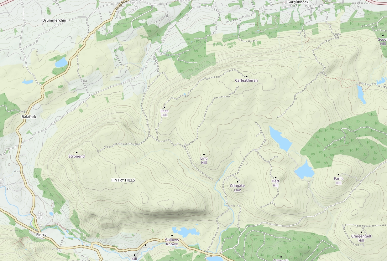
Stronend and the Fintry Hills
|
Details last updated: |
2024-21-07 |
|
Site Owner / Negotiator |
LLSC |
|
Site Contact |
|
|
Special Rules: |
Sensitive lambing area lambing restrictions between 1st April and 31 May. |
|
Site History: |
A fine range of hills for the paraglider pilot with 7 regularly used launch sites and many more options. The description below has been limited to Stronend which tends to have the most reliable conditions due to its position. In favorable northerly weather a fine ridge run is possible right along the range. |
|
Altitiude at Launch: |
1550 Feet |
|
Height top to bottom: |
1200 Feet |
|
Airspace: |
Glasgow CTA overhead at 3000 feet. Glasgow CTR 2 miles south. |
|
National Grid Reference: |
NS613899 |
|
Wind Direction: |
NNW to SW |
|
Brief Site Description: |
Long ridge facing NW and curving round to W and SW. Prevailing winds and local topography often produce favorable soaring conditions on Stronend which can be quite thermic. Buckies West and Buckies East are further east but usually only the east facing slope is flown. The ridge continues to extend for several miles to the east where Gargunnock provides fine soaring in more Northerly conditions. Launch is possible almost anywhere south of Stronend all the way to Double Craigs. It is reported than it can get rough in more westerly conditions. Loch Walton further south again is a large south facing slope but is seldom flown due to winds tending to funnel along the Carron Valley. |
|
How to get there: |
Head for Fintry 20km north of Glasgow. Several options for parking. Before and after refreshments available at Finrty sports club. |
|
Restricted Areas: |
landing areas on the north side of the Fintry Hills are sensitive during lambing period. See above. |
|
Parking Notes: |
Either at a small copse about 400 m off the B822 Fintry to Kippen road room for two cars. Here Or at Fintry sports club, open to the public good refreshments if there are no matches on. Here Culcreuch Castle hotel is now closed and the road is closed to vehicles. Do not drive up the farm track. |
|
Landowners: |
|
|
CANP |
Raising a CANP for this site is not recommended. |
|
Launch Notes: |
Northern approach from the copse car park head directly towards the nose of Stronend passing new forestry on the left then very steeply up, the best route is straight up following the fence on your left, with a small zig zag through the final steep summit crags. Large grassy slopes with many launch options. From the sports club head up the road to Culcreuch Castle follow the track to the right of the castle and follow the farm track which eventually trends north up through pleasant countryside till you emerge on the open hill where you can take the line of least resistance to the top and launch anywhere on the ridge. Other launch sites at Buckies East and West, Double Craigs, Loch Walton and Gargunnock. |
|
|
|
|
XC Tips: |
Not generally considered suitable for XC due to airspace overhead but a fine ridge run is possible in northerly conditions right along the range. |
|
Top Landing Notes: |
North end of Stronend has a very rounded crest and large plateau area suitable for top landing. |
|
Bottom Landing Notes: |
Large easy to reach landing field by the copse car park. The field just east of the parking place is preferred but keep clear of horses near the farm. If there appear to be too many sheep land to the north of the road. If walking up from the sports club or castle there are various options to the East of the village near the castle and the large field by the Endrick but check you have sufficient height to reach them. If in doubt use the north landing which is large and easy to reach. Bold pilots have been known to land on the rugby field. |
|
|
|
|
Hazards: |
Airspace at 3000 feet. Make sure your altimeter is calibrated. Beware light aircraft following the Endrick valley to Cumbernauld airport. The north end of the ridge has a well rounded crest but further south has a sharp cliff edge which may produce rotor if you get too far back. Take care not to get too low at the south end of the ridge as the site has an extensive plateau below the soaring face which is rough and uneven in places and may result in a walk. |